Compaction compliance in Waterford cannot rely on guesswork. The county’s glacial tills and alluvial silts along the River Suir demand precise field verification. The sand cone method – covered under IS EN 13286-2 and SR 21 – delivers the direct density reading that nuclear gauges cannot always provide in layered fill. Waterford’s wet climate accelerates moisture variation in compacted lifts. A field density test catches weak zones before they turn into settlement failures. For platform validation on commercial developments near the Quays, the data must be immediate and repeatable. Our laboratory operates to ISO 17025, with technicians who know the local ground profile from Ferrybank to Kilmeaden. Each test produces a verifiable dry density value, tied to the reference Proctor curve for the material on site. No generic assumptions. No delayed reporting. Just a reliable number that the resident engineer can sign off on the same day.
A compaction percentage without a verifiable field density test is just an opinion. In Waterford’s mixed glacial soils, the sand cone gives the only direct measurement that holds up in arbitration.
Technical details of the service in Waterford
Demonstration video
Local geotechnical conditions in Waterford
Waterford’s subsoil is a patchwork of glacial boulder clay overlying sandstone and shale bedrock. Near the River Suir floodplain, soft alluvial deposits extend several metres deep. A poorly compacted fill over these silts can lose bearing capacity after heavy rainfall. The field density test is the last line of defence before paving or slab placement. Without it, differential settlement appears within months. The sand cone method has one key vulnerability: moisture in the calibration sand. In Waterford’s damp conditions, we replace and re-calibrate sand at shorter intervals than the standard. Operator technique also matters. Excavation must be clean and undisturbed. A sloppy hole produces false high density. Our technicians follow the SR 21 Annex procedures exactly. The result is a defensible compaction record that protects both the contractor and the client.
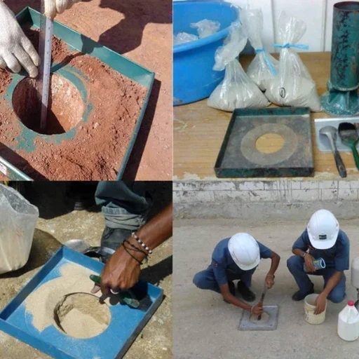
Our services
We carry out sand cone field density testing across Waterford city and county. Our work covers road sub-base, trench reinstatement, and building platforms. Two core service packages apply:
Road & Utility Compaction Verification
Field density tests for Type 1 and Type 2 sub-base on Waterford’s road schemes. We follow SR 21 frequency tables and deliver same-day reports to the site engineer. Each test location is GPS-tagged.
Building Platform & Hardstanding Testing
Compacted fill verification under commercial floor slabs and external hardstandings. We test each lift before the next is placed. Results include percentage air voids and Proctor comparison.
Questions and answers
How much does a field density test cost in Waterford?
The sand cone field density test typically ranges from €100 to €140 per location. The final rate depends on the number of points per visit, travel distance within the county, and whether moisture content determination by oven drying is included. We provide a fixed quote after confirming the project’s testing schedule.
Which standard applies to the sand cone test in Ireland?
The test method follows IS EN 13286-2. The procedural guidance for roads and earthworks in Ireland comes from SR 21:2016+A1:2020. This document specifies the frequency of testing, acceptance criteria, and reporting format for compacted unbound materials.
How many tests are needed for a trench reinstatement?
SR 21 Table 2 defines the minimum frequency based on trench length and fill volume. Typically, one test per lift every 25 linear metres is required, but the supervising engineer may increase this if the material or weather conditions change during the works. More info.