In Waterford, what you see on the surface rarely tells the full story of what lies beneath. A site that looks solid on a sunny afternoon can hide solution features in the limestone bedrock, pockets of soft alluvium along the Suir, or perched groundwater that only becomes apparent once excavation starts. We have worked on projects across the city—from the quays redevelopment to residential schemes on the outskirts near Tramore Road—where a rapid electrical resistivity survey identified buried paleochannels that conventional boreholes had missed. The VES method, which we run with a Schlumberger array to reach depths of 30 to 40 metres, gives us a continuous vertical profile of apparent resistivity. This allows us to interpret layer thicknesses, water table position, and changes in lithology without the disturbance that comes with drilling. When combined with targeted test pits for calibration, the geoelectrical model becomes a reliable tool for planning foundations, infiltration systems, and cut slopes in the variable glacial and post-glacial deposits that characterise this part of the southeast.
The real value of a VES survey in Waterford is not just finding the bedrock—it is knowing whether that bedrock is solid limestone or a weathered zone full of clay-filled cavities.
Technical details of the service in Waterford
Local geotechnical conditions in Waterford
Under IS EN 1997-2:2007, ground investigation in karst-prone terrain must address the risk of sudden change in bearing stratum, and the National Annex for Ireland explicitly references the need for geophysical methods where dissolution features are suspected. Waterford sits on Carboniferous limestone that has been subjected to millennia of chemical weathering, so the probability of encountering a clay-filled epikarst zone or a void beneath a thin rockhead is not trivial. A resistivity survey that skips calibration against borehole control can produce a beautifully smooth inversion that completely misses a 2-metre-wide cavity, and the consequences of such an omission—differential settlement, sudden collapse during piling, or water ingress into a basement—are both expensive and dangerous. We reference the methodology outlined by the GSI in their guidance on karst hazard assessment, and we always run at least two orthogonal soundings or a short 2D profile when the geology suggests anisotropy. The data is interpreted conservatively, flagging any zone where resistivity exceeds 1000 Ωm as potential voiding until proven otherwise by intrusive investigation.
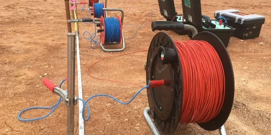
Our services
Our electrical resistivity services in Waterford are structured to cover the full investigation cycle, from reconnaissance profiling to detailed VES interpretation and integration with the geotechnical ground model.
Vertical Electrical Sounding (VES)
Single-point Schlumberger soundings to map layer thickness, bedrock depth, and water table across a site, with 1D inversion calibrated to local borehole data.
2D Electrical Resistivity Tomography
Multi-electrode profiles for imaging lateral variations along proposed pipeline routes, road alignments, or across suspected karst features.
Groundwater and Aquifer Assessment
Resistivity surveys combined with water quality sampling to delineate freshwater lenses, saline intrusion boundaries near the Suir estuary, and potential well locations.
Karst Hazard Mapping
Targeted resistivity grids over limestone terrain to identify low-resistivity clay-filled depressions and high-resistivity void zones before foundation or piling design.
Questions and answers
How deep can a VES survey investigate in Waterford’s geology?
With a maximum AB/2 current electrode spacing of 150 metres, we can reliably image down to approximately 40 to 45 metres in the glacial till and limestone sequences typical of the Waterford area. The actual depth of investigation depends on the resistivity contrast between layers; conductive estuarine clays near the River Suir will attenuate the signal faster than the drier gravels found on the terrace deposits, so we adjust the electrode spread accordingly.
What does an electrical resistivity test cost in Waterford?
For a standard VES sounding with full interpretation and a report referenced to IS EN 1997-2, the cost typically ranges from €580 to €1010 per location, depending on the maximum depth required, the number of soundings, and site access conditions. A 2D resistivity profile with multiple electrodes will be priced per linear metre and generally falls within a similar budget range when averaged per investigation point.
Can resistivity tell the difference between solid limestone and a clay-filled cavity?
Partially. Solid limestone typically shows resistivity above 800 Ωm, while a clay-filled cavity or epikarst zone will read much lower—often below 80 Ωm—because of the conductive clay minerals. An air-filled void will appear as a very high resistivity anomaly. The challenge is that a thin, dry rock layer over a clay pocket can produce a similar curve to massive limestone, which is why we always recommend at least one borehole or probe for calibration before finalising the interpretation.
Is electrical resistivity affected by the tide in Waterford?
Yes, and this is something we monitor carefully on sites close to the Suir estuary. The tidal range in Waterford Harbour can exceed 4 metres, and the associated fluctuation in groundwater salinity changes the bulk resistivity of the saturated zone. We schedule soundings during a stable tidal window and, where necessary, take conductivity measurements of nearby surface water to correct the inversion model for saline influence.
How long does it take to get results from a resistivity survey?
Fieldwork for a single VES sounding takes 30 to 60 minutes on site, plus setup time. We typically deliver a preliminary geoelectric section within two working days so that the design team can progress the ground model, and the final report with calibrated inversion profiles, interpreted stratigraphy, and correlation to any borehole logs follows within five to seven working days.