Waterford’s layered history as Ireland’s oldest city, founded by Vikings on the banks of the Suir, has left a patchwork of made ground and alluvial deposits across its urban core. The medieval streets of the Viking Triangle sit atop soft estuarine silts and organic clays that accumulated in the tidal reaches of Waterford Harbour, creating a geotechnical environment where particle size distribution governs everything from drainage design to foundation settlement predictions. Our laboratory on the quays processes hundreds of samples each month from the city’s ongoing regeneration projects — from the North Quays Strategic Development Zone to residential schemes in Ferrybank — where knowing the exact proportion of gravel, sand, silt, and clay is not a research exercise but a contractual obligation under the current Building Regulations and Eurocode 7. A single poorly graded silty sand lens, if missed in the particle size curve, can alter the liquefaction susceptibility assessment for a multi-storey structure by an entire risk category, which is why we combine mechanical sieve shaking with sedimentation hydrometer analysis on every cohesive sample that arrives from Waterford boreholes.
A 2% shift in clay content can change the Unified Soil Classification from SM to SC — enough to trigger a different foundation design approach under Eurocode 7.
Technical details of the service in Waterford
Local geotechnical conditions in Waterford
The alluvial deposits underlying Waterford city centre contain interbedded lenses of peat and soft organic silt — particularly in the areas south of the River Suir around Bilberry and west toward John’s River — where the fines content routinely exceeds 60%. These soils carry a documented history of differential settlement affecting nineteenth-century masonry buildings and modern infill developments alike. When a grading curve misclassifies a silty clay as a clayey silt simply because the hydrometer was read at 20°C instead of correcting for the actual 14°C winter lab temperature, the resulting design parameters for consolidation settlement can be off by a factor that compounds over a 50-year service life. Waterford’s groundwater table, sitting at less than 2 m depth across much of the floodplain, adds the complication of fully saturated conditions where effective particle size directly controls permeability and consolidation rate. Skipping the full hydrometer procedure on a sample that contained 15% clay — because it "looked sandy" at the sieve stage — is the kind of shortcut that turns a routine housing scheme into a Party Wall dispute six months after handover.
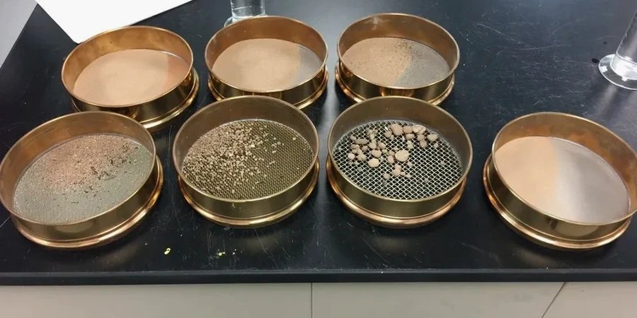
Our services
Our Waterford laboratory runs the full suite of particle size methods under one INAB-accredited quality system, ensuring every grading curve from the southeast region meets the traceability requirements of the National Annex to Eurocode 7. Whether the project is a single borehole for a house extension in Dunmore Road or a programme of 40 trial pits across the North Quays, the same calibration protocols and technician oversight apply.
Combined Sieve & Hydrometer (Full Grading Curve)
The complete particle size distribution from 75 mm down to the clay fraction (<2 µm). Required for soil classification to I.S. EN ISO 14688-2 and for any geotechnical design involving cohesive alluvial soils. Includes calculation of D10, D30, D60, Cu, and Cc coefficients.
Wash Sieving & Fines Content Only
A faster determination of the percentage passing the 63 µm or 75 µm sieve by wet washing, without the full hydrometer sedimentation curve. Suitable for granular soils and aggregate compliance checks where the fines threshold is the contractual pass/fail criterion.
Hydrometer Analysis on Cohesive Samples
Standalone sedimentation analysis for samples that have already been dry-sieved. We apply the full 24-hour reading schedule with temperature correction and dispersant control, delivering the silt and clay fractions required for liquefaction screening or consolidation modelling.
Questions and answers
What is the cost of a combined sieve and hydrometer grain size analysis in Waterford?
For a standard combined sieve and hydrometer analysis on a single sample, the cost typically ranges from €90 to €180, depending on whether the sample is predominantly granular (requiring less sedimentation time) or cohesive (requiring the full 24-hour hydrometer schedule). Bulk rates apply for ground investigation programmes involving 10 or more samples.
Which Irish standard governs particle size distribution testing?
The primary standard is I.S. EN ISO 17892-4:2016, which specifies the combined sieve and sedimentation method for determining particle size distribution. This sits within the Eurocode 7 framework under I.S. EN 1997-2 and is referenced by the Building Regulations Technical Guidance Document A for foundation design.
How long does a full grain size analysis take from sample receipt to report?
The sieve portion can be completed within one working day. The hydrometer sedimentation phase requires a minimum 24-hour reading cycle, so the combined test typically has a turnaround of 3 to 4 working days from sample receipt to the issued report. Expedited service within 2 working days is available for urgent Waterford projects.
What sample mass do you need for a reliable hydrometer analysis?
We require approximately 50 g to 100 g of material passing the 2 mm sieve for the hydrometer portion, depending on the anticipated clay content. For the full combined test, the total sample submitted should be at least 500 g for predominantly granular soils and 200 g for fine-grained soils, collected in a sealed bag to preserve the natural moisture content. More info.